
27 August 2026
Monsoon Flood Risk in Pakistan: Understanding the Threat and Building Resilience
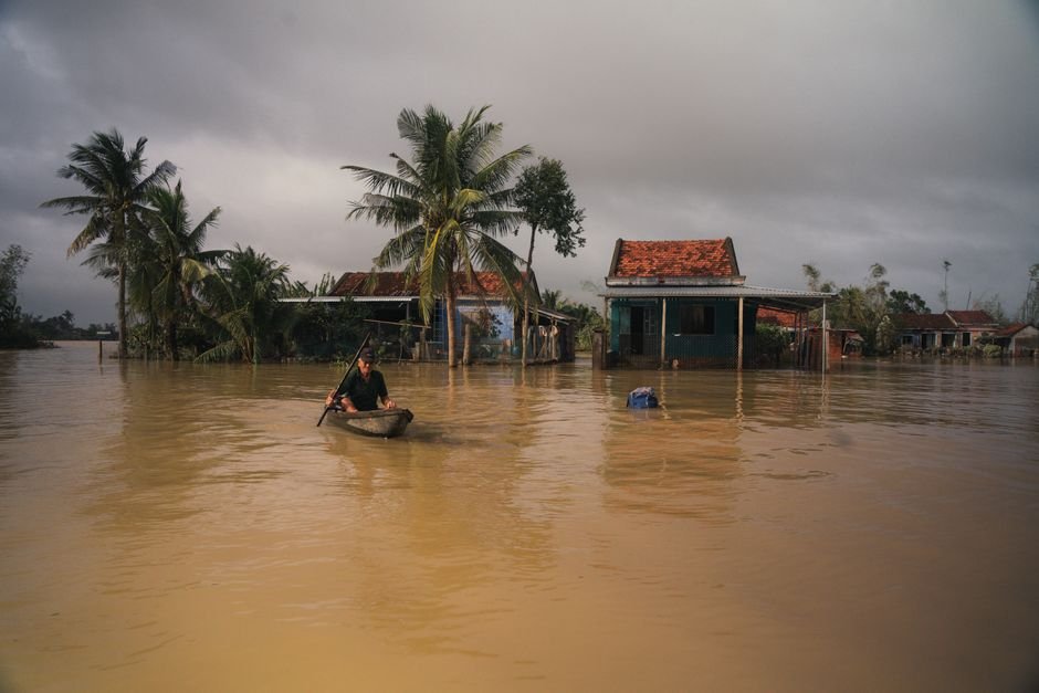
Why Monsoon Flooding Remains Pakistan's Most Destructive Climate Hazard
Monsoon flood risk in Pakistan is not a seasonal inconvenience. It is a recurring national crisis that displaces millions, destroys agricultural land, overwhelms infrastructure, and sets back development gains by years. The 2022 super floods, which inundated roughly one third of the country's land area and affected over 33 million people according to government and UN assessments, brought this reality into sharp global focus. But the 2022 event was not an anomaly. It was a severe expression of a trend that environmental professionals, disaster managers, and climate scientists have been tracking for decades.
Understanding why Pakistan is so exposed to flood risk, how that risk is changing under climate pressure, and what practical steps can reduce harm is essential knowledge for anyone working in environmental management, urban planning, agriculture, or public policy in this country.
The Geography and Climate Drivers of Flood Risk
Pakistan sits at the intersection of several converging hazard systems. The South Asian monsoon, which typically arrives in Sindh and Balochistan in late June and moves northward through July and August, delivers the bulk of the country's annual rainfall in a compressed period. The Indus River and its major tributaries, including the Jhelum, Chenab, Ravi, Sutlej, and Kabul rivers, drain an enormous catchment area spanning Pakistan, India, Afghanistan, and China. When heavy rainfall coincides across multiple sub-catchments, river flows can surge dramatically within days.
Several geographic factors amplify this baseline risk:
- Steep upper catchments: Glaciated and high-altitude terrain in Gilgit-Baltistan and Khyber Pakhtunkhwa generates rapid runoff with little storage capacity.
- Flat floodplains: The vast alluvial plains of Punjab and Sindh offer limited natural drainage gradient, meaning floodwaters spread widely and recede slowly.
- Deforestation: Significant loss of forest cover in upper watersheds has reduced rainfall interception and increased surface runoff velocity. Pakistan's forest cover remains low, estimated at around 4 to 5 percent of total land area, well below the internationally recommended threshold of 25 percent for ecological stability.
- Degraded wetlands: Natural floodplain wetlands that historically absorbed excess water have been encroached upon, drained, or converted to agriculture and urban use.
How Climate Change Is Altering the Risk Profile
Climate change is not simply making Pakistan wetter. It is making rainfall more erratic, more intense, and less predictable. The Intergovernmental Panel on Climate Change has documented that South Asia is experiencing increases in the frequency and intensity of extreme precipitation events, a pattern consistent with what Pakistan has observed on the ground. Warmer temperatures also accelerate glacial melt in the Karakoram, Hindu Kush, and Himalayan ranges, contributing to higher dry-season river flows and increasing the risk of glacial lake outburst floods, known as GLOFs.
Pakistan has one of the highest concentrations of glaciers outside the polar regions, with over 7,000 glaciers in its northern mountain ranges. As these glaciers retreat and melt unevenly, they form unstable glacial lakes that can breach suddenly and send walls of water and debris down valley systems with little warning. The National Disaster Management Authority has identified hundreds of potentially dangerous glacial lakes in Gilgit-Baltistan and Khyber Pakhtunkhwa.
At the same time, rising sea surface temperatures in the Arabian Sea are intensifying the moisture content of monsoon systems, meaning that when heavy rainfall events do occur, they carry more water. The 2022 floods were linked in part to an exceptionally active monsoon amplified by record sea surface temperatures, a pattern that climate projections suggest will become more common, not less.
Vulnerability Is Not Evenly Distributed
Flood risk falls hardest on communities that are already economically marginalised. In rural Sindh and southern Punjab, smallholder farmers who cultivate low-lying land near rivers face the greatest exposure. Their homes are often built from non-engineered materials that cannot withstand inundation. They lack savings, insurance, or alternative livelihoods to fall back on when crops are destroyed and animals lost.
Women and children face particular risks during flood events, including reduced access to safe shelter, sanitation, and healthcare. Post-flood disease outbreaks, including cholera, malaria, and dengue fever, have repeatedly followed major inundation events in Pakistan, compounding the immediate physical damage with public health emergencies that stretch for months.
Urban areas are not insulated from this risk. Rapid, poorly planned urban expansion in cities such as Karachi, Hyderabad, and Peshawar has placed large populations in flood-prone zones. Inadequate stormwater drainage infrastructure means that even moderate rainfall events can cause serious urban flooding. The encroachment of nullahs (natural drainage channels) by informal settlements and commercial construction is a well-documented problem that reduces drainage capacity precisely where it is most needed.
The Regulatory and Policy Framework
Pakistan's disaster risk management framework is anchored by the National Disaster Management Act 2010, which established the National Disaster Management Authority and its provincial counterparts. Provincial Disaster Management Authorities in Punjab, Sindh, Khyber Pakhtunkhwa, and Balochistan are responsible for preparedness, response, and recovery coordination at the provincial level.
On the environmental side, the Pakistan Environmental Protection Act 1997 and its provincial equivalents provide the legal basis for environmental impact assessment requirements and pollution control. Environmental Impact Assessments and Initial Environmental Examinations are legally required for development projects that could affect drainage, floodplains, or watercourses. In practice, enforcement of these requirements in flood-prone areas has been inconsistent, and development pressures have frequently overridden environmental safeguards.
Pakistan's National Flood Protection Plan and successive versions have outlined structural and non-structural flood management measures, including embankment construction, river training works, and early warning systems. The Ministry of Climate Change and Environmental Coordination has also incorporated flood risk reduction into Pakistan's updated Nationally Determined Contribution submitted under the Paris Agreement, recognising adaptation as a central national priority. Independent verification of implementation progress against these plans is important, and environmental professionals play a key role in that accountability function.
Practical Approaches to Reducing Flood Risk
Structural flood defences, such as embankments, barrages, and flood retention ponds, have a role to play but cannot solve the problem alone. They are expensive, require continuous maintenance, and can create a false sense of security that encourages further settlement in high-risk areas. A more durable approach combines structural measures with nature-based solutions, improved land use governance, and community-level preparedness.
Nature-Based Solutions
Restoring riparian vegetation along riverbanks, rehabilitating degraded wetlands, and protecting upland forests reduces runoff velocity, increases infiltration, and provides natural buffering against flood peaks. Pakistan's Ten Billion Tree Tsunami programme, whatever its implementation challenges, reflects an acknowledgment that ecosystem restoration has a direct role in disaster risk reduction. Environmental professionals can contribute by ensuring that reforestation efforts prioritise native species in appropriate locations, rather than planting trees in grassland ecosystems where they do not belong.
Early Warning and Community Preparedness
Pakistan's flood early warning system, operated through the Federal Flood Commission and the Pakistan Meteorological Department, has improved in recent years. Advances in satellite-based rainfall monitoring and river gauge networks have extended warning lead times in some catchments. However, the last-mile challenge remains significant. Warnings issued at the national level do not always reach vulnerable communities in time, in accessible language, or through trusted channels. Community-based disaster risk reduction programmes, where local volunteers are trained to understand flood signals and coordinate evacuation, have shown practical value in several districts.
Land Use Planning and Building Standards
Restricting construction in high-risk floodplain zones, enforcing setbacks from riverbanks, and requiring flood-resilient design for infrastructure in exposed areas are measures that can significantly reduce future losses. These require coordination between environmental regulators, urban planning authorities, and revenue departments, a coordination that is often difficult but not impossible to achieve.
Flood Insurance and Social Protection
The near-total absence of affordable flood insurance for smallholder farmers and low-income urban households means that recovery after each flood event depends almost entirely on government relief and international aid, both of which are slow, uneven, and insufficient. Developing parametric insurance products linked to rainfall or river level thresholds, as has been piloted in other climate-vulnerable countries, deserves serious attention from Pakistan's financial regulators and development partners.
The Role of Environmental Professionals
Environmental professionals in Pakistan are positioned at the intersection of science, policy, and practice in ways that matter directly for flood risk. Those conducting EIAs for infrastructure projects in flood-prone areas carry a direct responsibility to assess and communicate flood exposure honestly, even when clients prefer optimistic assessments. Those working in urban planning, watershed management, or climate finance have opportunities to advocate for and implement risk-reduction measures that compound over time.
Equally important is the role of environmental professionals in communicating flood risk to the public, to decision-makers, and to the media in ways that are accurate, clear, and actionable. Sensationalism and fatalism are both unhelpful. What communities and governments need is credible, specific information about where risk is highest, what interventions work, and what investment is required.
PAEP supports its members working across these areas through professional development events, policy engagement, and a network of practitioners in Islamabad, Punjab, and Sindh. If you are working on flood risk, climate adaptation, or disaster risk reduction in Pakistan, connecting with the PAEP community can provide access to peer knowledge, collaboration opportunities, and a platform to share your work.
Frequently Asked Questions
Q1. What causes monsoon flooding in Pakistan?
Monsoon flooding in Pakistan results from a combination of intense seasonal rainfall, rapid runoff from deforested and steep upper catchments, and the limited capacity of the Indus river system and its tributaries to absorb sudden surges in flow. Climate change is intensifying rainfall events and accelerating glacial melt, both of which increase flood frequency and severity.
Q2. Which parts of Pakistan are most at risk from monsoon floods?
Sindh and southern Punjab are historically the most flood-affected regions due to their flat topography and proximity to major rivers. Khyber Pakhtunkhwa and Gilgit-Baltistan face significant risk from flash floods and glacial lake outburst floods. Urban areas including Karachi and Peshawar experience serious urban flooding due to inadequate drainage infrastructure.
Q3. What is Pakistan's legal framework for flood and disaster management?
The primary legal instrument is the National Disaster Management Act 2010, which established the National Disaster Management Authority and provincial disaster management authorities. Environmental safeguards relevant to flood risk, including EIA requirements for development in sensitive areas, are governed by the Pakistan Environmental Protection Act 1997 and its provincial equivalents.
Q4. How does deforestation increase flood risk in Pakistan?
Forest cover intercepts rainfall, slows surface runoff, and promotes soil infiltration. When forests are cleared, rainfall reaches rivers faster and in greater volumes, increasing flood peaks. Pakistan's low forest cover, estimated at around 4 to 5 percent of land area, means that upper watersheds offer limited natural buffering against heavy rainfall events.
Q5. What are nature-based solutions for flood risk reduction?
Nature-based solutions include restoring riparian vegetation along riverbanks, rehabilitating floodplain wetlands that absorb excess water, protecting and expanding upland forest cover, and managing agricultural land to reduce runoff. These approaches work best when integrated with structural measures and strong land use governance rather than used in isolation.
Q6. How can environmental professionals contribute to reducing flood risk in Pakistan?
Environmental professionals contribute through rigorous EIA practice that honestly assesses flood exposure for development projects, through watershed management and restoration work, through climate adaptation planning, and through clear public and policy communication about risk. Professional networks such as PAEP provide platforms for knowledge-sharing and collaboration across these areas.